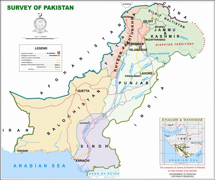
Pakistan Regulates Geospatial Data but Objects to India’s Map Bill
Pakistan’s complaint to the United Nations (May 17, 2016) that India’s draft Geospatial Information Regulation Bill is a violation of UN Security Council resolutions on Kashmir is overblown; in fact it is yet another instance of the pot calling the kettle black, which comes natural to Pakistan.
For the record let it be noted that Pakistan itself has enacted such a law two years ago. Its ‘Surveying and Mapping Act, 2014’ aims to regulate the production of geo-spatial data by empowering the Survey of Pakistan as the nodal agency. It elevates any inaccuracy in the Pakistan map to the level of security risk to the state. And asks clearly and unambiguously “unqualified/unregistered” firms “not to take part in Surveying and Mapping activities that can pose”.
India’s goal is rather very simple. It does not want any wrong depiction of its international boundaries particularly in today’s digital age. The penalties provided in the draft bill have drawn flak from several quarters on the ground that it stifles digital innovation but that is an internal matter of India. It is for the Indian parliament to address such criticism while ensuring that there is no wrongful depiction of India’s international boundaries in maps.
Anyhow the bill when finally tabled in parliament may not necessarily be a replica of the draft that has been put in public domain. After introduction the bill will go before the Standing Committee of the Home and IT ministries, which will fine tune the provisions of the new law. This is a check inbuilt into the Indian system of governance, which is respected by the executive – something that is alien to Pakistan despite the trappings of democracy because of domination of the military establishment in the nation’s affairs.
So much so, the song and drama Pakistan has opted to stage on the Indian bill is, well, no more than song and drama.
Pakistan’s case is that ‘through the passage of this Bill, the Indian government would penalise the individuals and organizations who depict Jammu and Kashmir as a disputed territory as per the United Nations Security Council (UNSC) resolutions.” Pakistan’s permanent representative to the UN, Maleeha Lodhi has shot off her complaint to the UN secretary general Ban Ki-Moon and the UNSC President. The same argument was articulated by the Pakistan foreign office through a press release.
India’s claim of Kashmir as an integral part of its territory is a “travesty of history, morality, international law and facts on the ground”, Ms Lodhi told UN, and said that the proposed Indian law is matter of serious concern to Pakistan. In a manner of speaking, Pakistan views the Indian law as yet another talking point, and wants to score a brownie point.
No one will like to quarrel with the Pakistani mandarins who are truly the original argumentative South Asians but it is difficult to resist the temptation to ask the question: what happened to these very concerns when Pakistan enacted its anti-map distortion law after mulling for over two years. The draft bill was introduced in the National Assembly (Parliament) in 2012. It became a law in 2004.
Interestingly the Pakistani law does not explicitly bar the “wrong depiction” of the country’s official map. It does provide penalties for anyone engaging in unauthorised “geospatial data production”. These penalties are less strident than the Indian bill’s prescriptions even while seeking to, as pointed at the outset, “stop unqualified/unregistered firms to take part in Surveying and Mapping activities that can pose a security risk to the state”.
India did not kick up a row with Pakistan on its law. It treated Pakistani map business as an internal matter of the land of the pure. India attaches no importance to how Pakistan depicts Kashmir in its maps since the Kashmir issue is a legacy of partition and remains on the agenda for bilateral talks.
The official Survey of Pakistan Map shows Jammu and Kashmir as a part of Pakistan while depicting them as disputed territory. And make no mention of Aksai Chin, which the Bhuttos had generously gifted to China, as if the territory was theirs. More over the official Pakistan map doesn’t adhere to the UN’s depiction of Kashmir.
Indian official spokesman’s response to Pakistani criticism was brief and to the point. “The proposed Bill is an entirely internal legislative matter of India, since the whole of the state of J&K is an integral part of India. Pakistan or any other party has no locus standi in the matter”, Vikas Swarup said on May 17, 2016. He added as if for emphasis: “The Government firmly rejects Pakistan’s repeated and increasing attempts to impose on the international community matters that India has always been open to address bilaterally with Pakistan”.
This doesn’t mean the last word has been said on the subject though Pakistan’s objections may not be more than a proforma exercise. One thing is clear though as of now. Once the Indian parliament clears the Geospatial Information Regulation Bill, mapmaking will become a much more serious enterprise for foreign entities doing business in and with India.
-
CHINA DIGEST
-
 ChinaChina Digest
China’s PMI falls for 3rd month highlighting challenges world’s second biggest economy faces
ChinaChina Digest
China’s PMI falls for 3rd month highlighting challenges world’s second biggest economy faces
-
ChinaChina Digest
Xi urges Chinese envoys to create ‘diplomatic iron army’
-
ChinaChina Digest
What China’s new defense minister tells us about Xi’s military purge
-
ChinaChina Digest
China removes nine PLA generals from top legislature in sign of wider purge
-
-
SOUTH ASIAN DIGEST
-
South Asian Digest
Kataragama Kapuwa’s arrest sparks debate of divine offerings in Sri Lanka
-
South Asian Digest
Nepal: Prime Minister Dahal reassures chief ministers on police adjustment, civil service law
-
South Asian Digest
Akhund’s visit to Islamabad may ease tensions on TTP issue
-
South Asian Digest
Pakistan: PTI top tier jolted by rejections ahead of polls
-


Comments